saniHUB RedBasica is an open-source software designed to support the planning and sizing of sanitary sewer networks. It offers specialized tools for designing condominial-type systems. The software functions as a plugin for QGIS, a free and powerful Geographic Information System (GIS).
It is recommended to always use the current stable (LTR) version, which can be checked on the website: https://qgis.org/en/site/.
The software was originally developed for the Inter-American Development Bank (IDB), the Spanish Agency for International Development Cooperation (AECID), and the Latin America Investment Facility – European Union (LAIF) with an educational purpose and to promote free access to modern tools for sanitary sewer network design.
The plugin takes the advantage of a huge amount of essential tools that already existis in QGIS, foe example all the drawing tools, georeferencing, attribute tables, and other, and adds over it functionalities to facilitate and automate the design process of sewer networks.
The plugin's developed tools include:
- Creation of pre-configured vector layers (segments, nodes,...) for project development;
- Naming of collectors (both manually or automatically);
- Linking between vector layers and their attributes;
- Custom styles and labels for each layer;
- Checking for potential project inconsistencies;
- Windows displaying attributes of the selected section and other project information;
- Tool for calculations and sizing of sewer collection networks directly within QGIS, with all calculation parameters editable;
- Importing results from hydraulic calculations back into the QGIS layout;
- Exporting results of the sized network to EPA SWMM software;
- Displaying the sizing result on the project layout;
- Visualization of the designed network profile;
- Possibility of exporting trace data for hydraulic calculations to other spreadsheets or external software, and later importing the results.
The link between QGIS modules and the calculation application is simplified using the plugin tools. If the user wants to export for external use (spreadsheet or software), this can be done through the export and import functions of comma-separated text files (“.csv”), containing basic information for sizing, such as: collector names, section names, section lengths, trace typology, terrain elevations, auxiliary notes made by the user during the project, etc.
Both the internal calculation application and the provided calculation spreadsheet (RedBasica) are based on the Brazilian standard for "Design of sanitary sewer collection networks" (NBR 9649), including the calculation of tensile stress. However, the calculation parameters can be freely adjusted by the user to suit local characteristics.
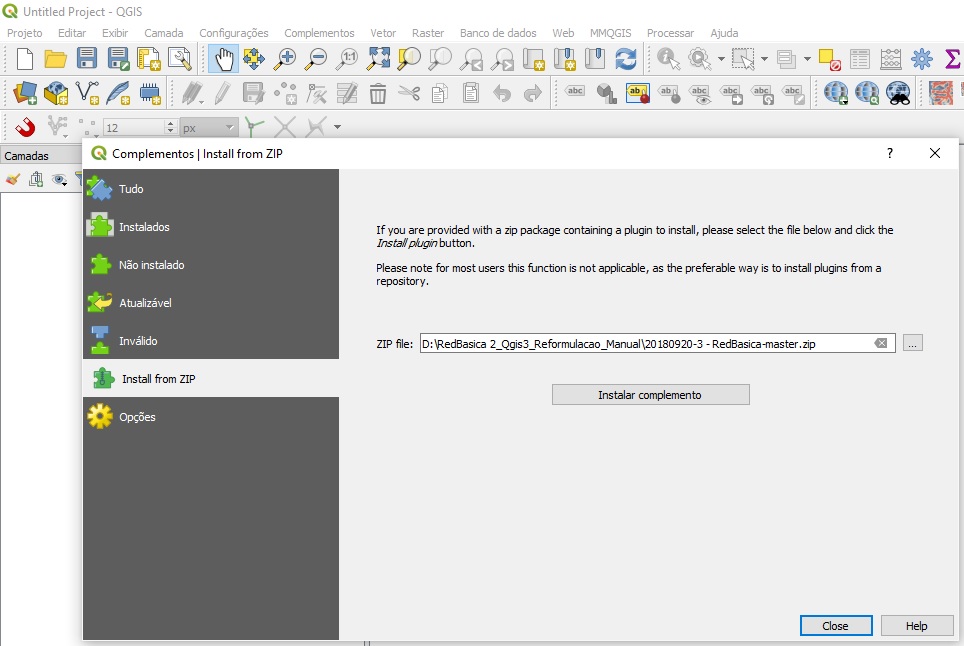
To install the saniHUB RedBasica plugin, the user must:
- Download the file available at the LINK;
- Using QGIS Version 3.0 or higher, open the Plugins > Manage and Install Plugins menu, select the Install from Zip option, and specify the location where the installer is located on your computer, as shown in the figure:
Currently, the complete manual for version 1.0, which includes the calculation application in QGIS, is under development. Additionally, there is a course available through the YouTube channel with translations in English, Spanish, and French. This course is also being updated to include new features.
The user can choose between using an existing vector layer (with an already traced network) or create a new one and trace it using QGIS drawing tools.
The standard attributes used by the plugin are listed below with their respective functions.
| Name | Description | Type | Size | Precision | Unit |
|---|---|---|---|---|---|
aux_pav_1 |
Street pavement type (e.g., asphalt = 1; cobblestone = 2; concrete block = 3) | string | 10 | - | - |
aux_pav_2 |
Sidewalk pavement type, same logic as street pavement | string | 10 | - | - |
aux_pos |
Preferred position annotation of the segment (0 = street, 1 = sidewalk) | string | 10 | - | - |
aux_Prof_f |
Depth assistance required at the downstream point of the current segment (due to interference or other factors) | string | 80 | - | - |
aux_Prof_i |
Depth assistance required at the upstream point of the current segment (due to interference or other factors) | string | 80 | - | - |
aux01 |
Generic auxiliary | string | 10 | - | - |
aux02 |
Generic auxiliary | string | 10 | - | - |
aux03 |
Generic auxiliary | string | 10 | - | - |
Caida_p2 |
Drop device at the downstream point of the segment | string | 80 | - | - |
Caida_p2_h |
Height of the drop device at the downstream point of the segment | string | 80 | - | m |
DN |
Nominal diameter of the collector | string | 80 | - | mm |
h_col_p1 |
Collector depth at the upstream (initial) point of the segment | string | 80 | - | m |
h_col_p2 |
Collector depth at the downstream (final) point of the segment | string | 80 | - | m |
h_tap_p1 |
Covering layer depth of the collector at the upstream (initial) point of the segment | string | 80 | - | m |
h_tap_p2 |
Covering layer depth of the collector at the downstream (final) point of the segment | string | 80 | - | m |
Id_Col |
Name of the collector | string | 10 | - | - |
Id_TRM_(n) |
Name of the segment of the collector (name and number of the current segment) | string | 10 | - | - |
L |
Length of the segment | real | 10 | 2 | m |
LABEL_VIS |
Label visibility helper (1 = visible, 0 = hidden) | integer | - | - | - |
LABEL_X |
Label X coordinate helper | real | 10 | 6 | m |
LABEL_Y |
Label Y coordinate helper | real | 10 | 6 | m |
Mat_col |
Pipe material | string | 80 | - | - |
n |
Manning coefficient of the segment | string | 80 | - | - |
Q_f |
Final flow rate adopted for the segment | string | 80 | - | l/s |
Q_i |
Initial flow rate adopted for the segment | string | 80 | - | l/s |
Qmax_f |
Maximum flow rate at the end of the plan, considering distributed flows, concentrated flows, infiltration, and the flow coefficients adopted in the project parameters | string | 80 | - | l/s |
Qmax_i |
Maximum flow rate at the beginning of the plan, considering distributed flows, concentrated flows, infiltration, and the flow coefficients adopted in the project parameters | string | 80 | - | l/s |
Qmed_f |
Average flow rate at the end of the plan, considering distributed flows and concentrated flows | string | 80 | - | l/s |
Qmed_i |
Average flow rate at the beginning of the plan, considering distributed flows and concentrated flows | string | 80 | - | l/s |
Qr_f |
Recurrent projected flow rate at the end of the plan (considering the hourly peak factor) | string | 80 | - | l/s |
Qr_i |
Recurrent projected flow rate at the beginning of the plan (considering the hourly peak factor) | string | 80 | - | l/s |
Vc_f |
Critical flow velocity at the end of the plan | string | 80 | - | m/s |
Vc_i |
Critical flow velocity at the beginning of the plan | string | 80 | - | m/s |
X_f |
X coordinate at the end point of the segment (downstream) | real | 10 | 6 | m |
X_i |
X coordinate at the starting point of the segment (upstream) | real | 10 | 6 | m |
Y_f |
Y coordinate at the end point of the segment (downstream) | real | 10 | 6 | m |
Y_i |
Y coordinate at the starting point of the segment (upstream) | real | 10 | 6 | m |
yn_f |
Liquid level in the collector - end of the plan | string | 80 | - | m |
yn_i |
Liquid level in the collector - beginning of the plan | string | 80 | - | m |
yrel_f |
Relative liquid level in the collector - end of the plan | string | 80 | - | % |
yrel_i |
Relative liquid level in the collector - beginning of the plan | string | 80 | - | % |
| Attribute Name | Description | Type | Size | Precision | Unit |
|---|---|---|---|---|---|
aux04 |
Generic auxiliary | string | 10 | - | - |
aux05 |
Generic auxiliary | string | 10 | - | - |
aux06 |
Generic auxiliary | string | 10 | - | - |
CF_nodo |
Bottom elevation of the inspection device | string | 80 | - | m |
Citrd_nodo |
Intrados elevation of the node | string | 80 | - | m |
CT_(N) |
Terrain elevation at the node (initial and final) | real | 10 | 2 | m |
h_nodo_NT |
Depth of the inspection device relative to ground level | string | 80 | - | m |
h_nodo_tp |
Depth of the inspection device relative to its cover | string | 80 | - | m |
Id_NODO_(n) |
Name of the current node (Inspection chamber or Manhole) | string | 80 | - | - |
Qi_cat |
Initial flow rate of the influence area originated from flow data (user registration) | real | 10 | 6 | l/s |
Qf_cat |
Final flow rate of the influence area originated from flow data (user registration) | real | 10 | 6 | l/s |
Qi_con |
Initial flow rate of the influence area originated from connections | real | 10 | 6 | l/s |
Qf_con |
Final flow rate of the influence area originated from connections | real | 10 | 6 | l/s |
Qi_pop |
Initial flow rate of the influence area originated from population data | real | 10 | 6 | l/s |
Qf_pop |
Final flow rate of the influence area originated from population data | real | 10 | 6 | l/s |
Id_UC |
Identification of the contributing block (block) | string | 10 | - | - |
LABEL_VIS |
Label visibility helper (1 = visible, 0 = hidden) | integer | 10 | - | - |
LABEL_X |
Label X coordinate helper | real | 10 | 6 | m |
LABEL_Y |
Label Y coordinate helper | real | 10 | 6 | m |
Nodo_tipo |
Type and size of the inspection device | string | 80 | - | - |
Tap_nodo |
Depth of the covering layer of the inspection device | string | 80 | - | m |
CF_NODO2 |
Elevation of the node calculated by depth estimation | real | 10 | 2 | m |
H_NODO_TP2 |
Depth of the node calculated by depth estimation | real | 10 | 2 | m |
| Name | Description | Type | Size | Precision | Unit |
|---|---|---|---|---|---|
Id_UC |
Identification of the contributing block (block) | string | 10 | - | - |
Qe_ip |
Number of contributing houses at the start of the plan | integer | 10 | - | un |
Qe_fp |
Number of contributing houses at the end of the plan | integer | 10 | - | un |
QConcI |
Concentrated flow rate at the beginning of the plan | real | 10 | 4 | l/s |
QConcF |
Concentrated flow rate at the end of the plan | real | 10 | 4 | l/s |
- Concept Analyst: Leonardo Porto Nazareth
- Development Coordination: Marta Fernandez
- Developers: Martin Dell' Oro and Federico Sanchez
- Hydraulic Modeling and Calculations: Leonardo Porto Nazareth and Pery Nazareth
The saniHUB RedBasica is a Copyleft software. It has free source code for updates and improvements, ensuring that any derivative products from the version available here are licensed under the same terms, and commercialization of such products is prohibited. License Terms: GNU GPLv3
For more details, visit the LICENSE link of the plugin.
Any questions, suggestions, or to report any issues can be sent to the email: leonazareth@gmail.com
If you are interested in contributing to the development of the plugin, please contact us via email: leonazareth@gmail.com